We have made it easy for you to transfer your motorcycle tours to any GPS device. Just install the program on your computer and experience how easy it is
Please install update of Tourstart Transfer. The new Tourstart Transfer have some fixes of bugs and the programs function has been improved
A journey through New Zealand for 3 weeks time with a 4 berth selfcontained campervan. We will arrive in Auckland the 24th of December and fly to Christchurch the 27th of December, were we will pick up the campervan. The campervan will be returned in Auckland the 18th of January. After that we will explore the nearbys of Auckland.
Hire of Campervan Explorer Auto 4 berth.
Vehicle Make: Volkswagen
Vehicle Dimensions:
Length - 7.22m
Width - 2.28m
Height - 3.25m
Interior Height - 2.15m
SafetyABS brakes
2 seatbelts in the driver's cab
2 seatbelts in the main cab
Driver and front passenger airbag
Child and Booster seat info
Personal safe
Other Features:
12 V battery / 240V mains
Air-con: Drivers Cab
Solar Panel
Heating: Drivers Cab + Main Cab
Internal Access
2WDAutomatic transmission
Power Steering
Engine: 2.5L Turbo Diesel
Fuel Capacity: 75L
Fuel: 12 litres per 100km approx.
External storage locker
Awning: included
Fresh water tank: 82L
Waste water tank: 82L
Hire bicycles may be fitted: x3
General Equipment:
Toilet chemicals
Dustpan and brush
Fire Extinguisher
Bucket & hose
Matches
Coat hangers
Clothes line & pegs
Biodegradable toilet chemicals
Dishwashing liquid sachet
Dishwashing cloth and scourer sponge
Bin and degradable bin liner
Vehicle Operation Guide
First Aid Kit (to be purchased if opened)
Travel Wallet
Travel GuideRoad maps
Discounts on New Zealand's leading attractions
Free supermarket discount card
Waitomo Glowworm Caves driver goes free
Complimentary Tourism Radio Guide
Free Travel App for your iPhone & Android smart phone
Akaroa, with its own beautiful bays and harbour, French and English history has an enormous range of activities to keep you busy for days. In Flea bay you will find the largest little penguin colony on mainland New Zealand. Akaroa waters are home to the rarest and smallest marine dolphin.
Broken River Skifield Road, Selwyn District, New Zealand
Arthur's Pass, Canterbury, NZ
Arthur's Pass is the highest pass over the Southern Alps. Long before surveyor Arthur Dudley Dobson found his way over the pass in 1864, it was known to Maori hunting parties as a route between east and west. The eastern side of Arthur's Pass National Park is characterised by wide, shingle-filled riverbeds and vast beech forests. The western side of the park, where wet weather is more common than dry, has deeply gorged rivers flowing through dense rainforest. Down the middle of 'the great divide' is an alpine dreamland of snow-covered peaks, glaciers and scree slopes.
Most people arrive in Arthur's Pass National Park by road - a spectacular piece of extreme civil engineering involving viaducts, bridges, rock shelters and waterfalls redirected into chutes. When Arthur Dobson first encountered the precipitous Otira Gorge, the pass was almost impassable - he had to leave his horse at the top and lower his dog on a rope.
The glacier is currently 12 km (7.5 mi) long and terminates 19 km (12 mi) from the Tasman Sea. Fed by a 20-square-kilometre (7.7 sq mi) large snowfield[7] at high altitude, it exhibits a cyclic pattern of advance and retreat, driven by differences between the volume of meltwater at the foot of the glacier and volume of snowfall feeding the névé.
The glacier advanced rapidly during the Little Ice Age, reaching a maximum in the early eighteenth century.[8] Having retreated several kilometres between the 1940s and 1980s, the glacier entered an advancing phase in 1984 and at times has advanced at the phenomenal (by glacial standards) rate of 70 cm a day. The flow rate is about 10 times that of typical glaciers. Over the longer term, the glacier has retreated since the last ice age, and it is believed that it extended into the sea some 10,000 to 15,000 years ago.
Haast Pass Makarora Road, SH 6, Queenstown-Lakes District, New Zealand
Wanaka, New Zealand
Kawarau Bridge, Queenstown-Lakes District, New Zealand
Oamaru, Otago, New Zealand
Penguins are a reason to stay a while in Oamaru. At sunset, little blue and yellow-eyed penguins waddle ashore to get comfortable for the night.
The whitestone townscape of Oamaru contains some of the best-preserved heritage buildings in New Zealand. In the late 19th century, the town prospered through goldmining, quarrying and timber milling. Some of the wealth was spent on elegant stone buildings made from local limestone. The Harbour-Tyne Street area is particularly special – and the shopping is great too. After exploring the Victorian precinct, swing by the steampunk playground and museum.
Oamaru Harbour is home to a colony of little blue penguins, and you can also see yellow-eyed penguins from a special hide. Penguin viewing is best just before sunset.
The public gardens in Oamaru are widely acclaimed. They include a Victorian summerhouse and an oriental garden.
Queenstown is the Southern Hemisphere’s premier four season lake and alpine resort. Queenstown’s stunning scenery, huge range of activities and renowned warm welcome cement its reputation as New Zealand’s favourite visitor destination. Surrounded by majestic mountains and set on the shores of crystal clear Lake Wakatipu, the natural beauty and the unique energy of the region create the perfect backdrop for a holiday full of adventure, exploration or relaxation.
Real Journeys offers an amazing opportunity to view the Te Anau Glowworm Cave. The tour begins with a scenic cruise across Lake Te Anau to the western side of the lake, on-board the catamaran Luminosa with live commentary. Upon arrival there is time to view informative displays at Cavern House before the friendly guides invite you to accompany them underground in small groups. As you explore by path and small boat, your senses will be overwhelmed. Observe how the rushing water sculpts the rock formations, before gliding through silent darkness to the glowworm grotto. The delicate incandescence of thousands of tiny glowworms is a magical sight. Experience the underground beauty of the Glowworm Caves on your next visit to the South Island of New Zealand, this is one tour not to be missed.
Visit New Zealand’s largest hydroelectric power station, the Manapouri Underground Power Station, located deep beneath Fiordland.
The construction of this power station was one of New Zealand's greatest engineering achievements, with the majority of the work completed underground in a remote location. The only external signs are the above-ground control building, a switchyard and two sets of transmission lines that loop across the head of the lake on their way to join the national grid.
Rare yellow-eyed penguins, fur seals and the world's only mainland albatross colony share residence in Dunedin, New Zealand's oldest city. When you're not watching wildlife, this South Island Otago Coast town also boasts impressive historic architecture from its days as a gold-rush mecca. Visit the 1906 Flemish Renaissance railway station or the country's largest center of higher learning, which resembles Glasgow University, thanks to the area's early Scottish settlers.
From Whitianga you can enjoy the beaches, water sports and boat excursions of Mercury Bay. Expect great seafood and enjoy a forest walk or two.
If you’re exploring the Coromandel Peninsula, you’ll soon come to Whitianga – the main town in Mercury Bay. When native forests were being harvested on the peninsula in the 1800s and early 1900s, Whitianga was a timber port. Ships from Europe sailed in to Whitianga's deepwater harbour to load up with valuable kauri. Today, the township depends on fishing, farming and tourism for its prosperity.
The Moeraki Boulders are unusually large and spherical boulders lying along a stretch of Koekohe Beach on the wave-cut Otago coast of New Zealand between Moeraki and Hampden. They occur scattered either as isolated or clusters of boulders within a stretch of beach where they have been protected in a scientific reserve. The erosion by wave action of mudstone, comprising local bedrock and landslides, frequently exposes embedded isolated boulders. These boulders are grey-colored septarian concretions, which have been exhumed from the mudstone enclosing them and concentrated on the beach by coastal erosion.
Local Māori legends explained the boulders as the remains of eel baskets, calabashes, and kumara washed ashore from the wreck of Arai-te-uru, a large sailing canoe. This legend tells of the rocky shoals that extend seaward from Shag Point as being the petrified hull of this wreck and a nearby rocky promontory as being the body of the canoe's captain. In 1848 W.B.D. Mantell sketched the beach and its boulders, more numerous than now. The picture is now in the Alexander Turnbull Library in Wellington. The boulders were described in 1850 colonial reports and numerous popular articles since that time. In more recent times they have become a popular tourist attraction, often described and pictured in numerous web pages and tourist guides.
Duntroon is home to the Vanished World Heritage Centre, dedicated to showcasing the geology of the Waitaki region and preserving fossils of extinct species that have been found in the region. These include two species of the penguin genus Archaeospheniscus, Lowe's penguin and Lopdell's penguin, found in the Kokoamu Greensand formation. The town is also located near two sites of centuries-old Māori rock drawings.
5 kilometres (3 mi) south of Duntroon, in the Maerewhenua Valley, a group of large rock formations called "Elephant Rocks" has been used as a filming location for the first Chronicles of Narnia movie in 2005.[2] The rock formations are located in a private field and can be seen from the road.
http://www.duntroon.co.nz/
Kurow, Canterbury, New Zealand
Kurow is a small town set in the Waitaki Valley in the Otago region. Kurow and the Waitaki District enjoy a huge range of activities including hunting, fishing, canoeing and jet boating.
Tekapo Twizel Road, SH 8, Mackenzie District, New Zealand
Christchurch, Canterbury, Neuseeland
Kaikoura, Canterbury, New Zealand
The picturesque coastal town of Kaikoura is the perfect place for marine life encounters, coastal walks, and tucking into a plate of crayfish.
Kaikoura is a base for wildlife experiences of all kinds – it’s also a great place to eat crayfish (in the Maori language 'kai' means food, 'koura' means crayfish). An easy two-hour drive north of Christchurch, Kaikoura makes for a great day trip or a fun stop on your way to Marlborough.
Kaikoura's environment is truly spectacular – the village is caught between the rugged Seaward Kaikoura Range and the Pacific Ocean. In winter the mountains are covered with snow, adding to the drama of the landscape.
Kaikoura’s special talent is marine mammal encounters – whales, fur seals and dolphins live permanently in the coastal waters. Whale watching trips leave the town several times a day and the local seal colony is always entertaining. There are plenty of cafés, restaurants and shops to explore.
The Coromandel Peninsula on the North Island of New Zealand extends 85 kilometres north from the western end of the Bay of Plenty, forming a natural barrier to protect the Hauraki Gulf and the Firth of Thames in the west from the Pacific Ocean to the east. At its broadest point, it is 40 kilometres wide. Almost the entire population lies on the narrow strips along the Hauraki Gulf and Bay of Plenty coasts. In fine weather the peninsula is clearly visible from Auckland, the country's biggest city, which lies on the far shore of the Hauraki Gulf, 55 kilometres to the west. The peninsula is part of the local government areas of Thames-Coromandel District and the Waikato Region.
Best known for its natural hot pools and stunning landscapes, Hanmer Springs is a picturesque alpine village 90 minutes' drive from Christchurch.
The resort town of Hanmer Springs is an attractive year-round holiday destination for adventure, relaxation and indulgence. Surrounded by dramatic mountains and towering forests, this charming town has a main street filled with boutique shops, cafes and eateries.
Adventure activities will immerse you in the wild beauty of Hanmer. Go forest hiking, mountain biking, horse trekking, bungy jumping, jet boating or, in winter, hit the slopes and go skiing. Once you've caught your breath, you might enjoy a leisure round of golf.
Don’t miss the iconic Hanmer Springs Thermal Pools and Spa where you can soak in naturally heated, mineral-filled waters or treat yourself to a range of indulgent spa therapies. The family fun area is complete with hydroslides and New Zealand’s only aquatic thrill ride, the Super Bowl.
Greymouth is a town with a history of jade hunting, gold mining and dramatic river floods. Sample the beer and listen to wild west coast stories.
Once the site of the Maori pa Mawhera (which means ‘wide spread river mouth’, in reference to the town’s river mouth location), Greymouth is the largest town on the South Island’s west coast. The area has a history of gold mining, which can be appreciated at the local museum and nearby Shantytown. The local brewery is something of a New Zealand legend; it runs tours that include a tasting session.
Other Greymouth entertainments include sea fishing, fly fishing, a quayside walk and hiking the Elizabeth Track, which passes through a scenic reserve and old goldmining sites. Around the town you’ll find galleries specialising in pounamu (New Zealand jade).
Punakaiki is a small community on the West Coast of the South Island of New Zealand, between Westport and Greymouth. The community lies on the edge of the Paparoa National Park.
The Pancake Rocks are a very popular tourist destination at Dolomite Point south of the main village. The Pancake Rocks are a heavily eroded limestone area where the sea bursts through several vertical blowholes during high tides. Together with the 'pancake'-layering of the limestone (created by immense pressure on alternating hard and soft layers of marine creatures and plant sediments), these form the main attraction of the area.
The Pancake Rocks are presently explorable by a number of walkways winding through the rock formations, parts of these wheelchair-accessible and others carved into stairways up and down the rock faces. State Highway 6, the only through road on the West Coast, passes through the town.
Picton is a town in the Marlborough Region of New Zealand's South Island. The town is located near the head of the Queen Charlotte Sound, 25 km (16 mi) north of Blenheim and 65 km (40 mi) east of Wellington. Waikawa lies just north-east of Picton, and is often considered to be contiguous part of Picton.
Picton is a major hub in New Zealand's transport network, connecting the South Island road and rail network with ferries across Cook Strait to Wellington and the North Island. The town has a population of 4,310 (June 2014 estimate), making it the second-largest town in the Marlborough Region behind Blenheim.
The town is named after Sir Thomas Picton, the Welsh military associate of the Duke of Wellington, who was killed at the Battle of Waterloo.
Kawakawa Bay is a small settlement facing North / North West on the Hauraki Gulf / |Firth of Thames. In the early days Kawakawa Bay was also known as Sandspit. In those days the horse was the sole means of transport and then the area was serviced by the ship "Hirere" captained by William Couldrey. Roads were later developed for the timber mills. As access to the area improved families moved into the area to farm the land. Descendants of those early Settlers are still in the area today farming the land or living locally. Those families include the Ashby, Deery, Couldrey, Cashmore, Renall, Luke, Munro and Adams families.
Kawakawa Bay has also been settled by the Maori. Evidence of that early occupation can still be seen today with the earthworks of Pa sites still visible on some headland sites. The first Bay is known to local as "Maori Bay" as many residents recall the Maori families still occupying that land up until the 1960s. There is still some local land in Maori ownership today. The Turei family was well known in the area, with the hill coming down into the Bay known as Turei Hill.
Wellington (/ˈwɛlɪŋtən/) is the capital city and second most populous urban area of New Zealand, with 393,600 residents. It is located at the south-western tip of the North Island, between Cook Strait and the Rimutaka Range. It is the major population centre of the southern North Island, and is the administrative centre of the Wellington Region, which also includes the Kapiti Coast and Wairarapa. Wellington is the world's southernmost capital city of a sovereign state.
The Wellington urban area comprises four cities: Wellington city, on the peninsula between Cook Strait and Wellington Harbour, contains the central business district and about half the population; Porirua on Porirua Harbour to the north is notable for its large Māori and Pacific Island communities; Lower Hutt and Upper Hutt are largely suburban areas to the northeast, together known as the Hutt Valley.
The 2014 Mercer Quality of Living Survey ranked Wellington 12th in the world. In 2011 Lonely Planet Best in Travel 2011 named Wellington as fourth in its Top 10 Cities to Visit in 2011, referring to it as the "coolest little capital in the world"
Sunk into a stunning volcanic landscape and surrounded by bush clad mountains is New Zealand's largest freshwater lake, Lake Taupo. The township of Taupo can be found on the banks of a large bay at northeast part of the lake, where it discharges to the mighty Waikato River.
The river flows over one of New Zealand's most spectacular waterfalls, Huka Falls, a short distance north of the town. The thundering Huka Falls is New Zealand's most visited natural attraction. More than 220,000 litres of water tumbles over the cliff face per second!
Taupo township is located right on the edge of the lake, and many hotels offer panoramic views over the lake to the snow-capped volcanoes of Tongariro National Park. Dine on the lakefront on a summer's evening or have fish and chips on the shore just like a local. Take in spectacular views while watching the sun sink behind the mountains.
A few minutes south of the Lake is Tongariro National Park. Gifted to the people of New Zealand by the Ngati Tuwharetoa tribe in 1887, the park is one of only a handful of sites in the world to be given dual World Heritage status for its cultural and natural importance. Experience the dramatic and eerie scenery with tramps through the park ranging from 2 hours to 6 days. Cover desolate fields of volcanic ash and scoria, rolling tussocklands, glacial valleys and tranquil lakes.
Lake Taupo Huka Falls
Taupo is a centre of volcanic and geothermal activity and hot springs suitable for bathing are located at several places in the vicinity, and stunning geothermal attractions litter the surrounding area. The Taupo Volcanic Zone stretches from Tongariro National Park all the way to White Island, and here you'll see spectacular steaming cliffs, geysers, boiling lakes, bubbling mud pools, floating rocks and beautiful volcanic plateaus.
The lake and its network of rivers offers a true wild trout fishing experience, bringing anglers from around the world. Skiers and snowboarders flood the region in winter time, drawn to Mt Ruapehu, with New Zealand's largest ski area. The region is also home to a number of adventure activities including sky diving, jet boating and paragliding, everything to satiate that lust for adventure.
Waitomo Caves
Waitomo Caves is a caves system and small village in the Waikato region of the North Island. The nearest large town, Hamilton, is one hour's drive away (78km) and Auckland, two hours away (200km) and Rotorua, two hours away (156km). The Waitomo Caves can be found 8km along Waitomo Caves Road, off State Highway 3.
Waitomo Caves village itself is very small, but the caves have formed a major tourist attraction and are well-known for their population of glowworms, Arachnocampa luminosa found exclusively in New Zealand. Visitors to the caves can visit easy-to-access caves, raft or crawl through caves depending on their interests and abilities. A popular guided activity is 'blackwater rafting' in which visitors float through the caves in huge tubes viewing glowworms and cave decorations as they go.
On the most picturesque private farmland you can visit the Hobbiton Movie Set from The Lord of the Rings and The Hobbit film trilogies in a fascinating two-hour guided tour.
The set has been completely rebuilt for The Hobbit and will remain as it was seen in these films and The Lord of the Rings film trilogy.
During your tour you will see Hobbit Holes, The Green Dragon Inn, The Mill, double arched bridge and other structures and gardens built for the films.
We very much look forward to welcoming you to Hobbiton Movie set.
Masterfully recreated, we invite you to relax at the Inn of the Hobbits as part of your tour. All guests recieve one complimentary refreshment from our exclusively crafted Southfarthing™ range.
The inn also offers traditional fare, including our famous beef and ale pie.
The Shires™ Rest cafe is conveniently located at the Entrance to Hobbiton Movie Set. You can relax and soak up the unique atmosphere with a great cup of coffee or a light meal.
Rotorua is one of the world's most spectacular Geothermal Wonderlands. Geothermal activity, from the Greek geo meaning earth and therme meaning heat, seethes from cracks in the streets, steams from backyard hot pools, bursts from geysers throughout the area, and bubbles from cauldron-like mud pools.
The phenomenal creativity of nature can be seen in all its glory right here in Rotorua. Multi-hued lichens, moss and salt structures blend harmoniously with lush native greens, crystal blue lakes and earth tones ranging from rust to ochre. Splendid examples of silicate and mineral formations rise from and mould into a landscape sculpted by the region's turbulent volcanic activity for thousands of years, and the resulting terraces, valleys and lakes are beyond beauty, they are nature's own art form.
Rotorua and its surrounding areas are charged with a primordial ambiance that challenges the auditory, visual and olfactory senses.
There are five main Geothermal Areas in which a variety of geysers, hot springs, boiling mud pools and hissing craters can be experienced up close.
The Bay of Plenty, known in Māori as Te Moana-a-Toi, is a large indentation in the northern coast of New Zealand's North Island. It stretches from the Coromandel Peninsula in the west to Cape Runaway in the east, a wide stretch of some 259 km of open coastline. The Bay of Plenty Region is situated around this body of water, also incorporating several large islands in the bay.
To get in contact with us please fill in the below form, and send it to us. Then we will reply to you shortly.
Thanks in advance,
Tourstart Team
|
Feedback
Hi ,
Thanks for taking time to send us a feedback with your findings. We are happy when our members give us some valuable feedback, as this is the only way we can improve our web site.
We will do our utmost to review your comments and make any corrections accordingly, as soon as possible.
The web site is using cookies to remember your settings, statistic and to target adverts. This information is shared with third party.
Read more
You need to confirm your e-mail address. Check your e-mail.
Login / Register
Read and accept the Legal Issues
New users can try Pro on web and navigation on iPhone and Android app free for 14 days. See full list of features here
Welcome.
Welcome. You are about to sign up to Tourstart – which we are happy about.
All you need to do is to click the “Register as a new user” button.
Stay signed in
I agree to all the Legal Issues and accept that I have read, understood and accepted these which can be read following this link
Copyright (c) 2008-2024 Tourstart ApS and its legal partners. All rights reserved. The following conditions apply to all code found on and used on Tourstart web pages.
Redistribution in any form and use in source and binary forms, with or without modifications, are not permitted in any case.
Further, it is not permitted to:
Distribution of source code.
Distribution in binary form.
Copy any source code whole or part hereof for any use
THIS SOFTWARE IS PROVIDED BY TOURSTART “AS IS” AND ANY EXPRESS OR IMPLIED WARRANTIES, INCLUDING, BUT NOT LIMITED TO, THE IMPLIED ARRANTIES OF MERCHANTABILITY AND FITNESS FOR A PARTICULAR PURPOSE ARE DISCLAIMED.
IN NO EVENT SHALL TOURSTART OR CONTRIBUTORS BE LIABLE FOR ANY DIRECT, INDIRECT, INCIDENTAL, SPECIAL, EXEMPLARY, OR CONSEQUENTIAL DAMAGES (INCLUDING, BUT NOT LIMITED TO, PROCUREMENT OF SUBSTITUTE GOODS OR SERVICES; LOSS OF USE, DATA, OR PROFITS; OR BUSINESS INTERRUPTION) HOWEVER CAUSED AND ON ANY THEORY OF LIABILITY, WHETHER IN CONTRACT, STRICT LIABILITY, OR TORT (INCLUDING NEGLIGENCE OR OTHERWISE) ARISING IN ANY WAY OUT OF THE USE OF THIS SOFTWARE, EVEN IF ADVISED OF THE POSSIBILITY OF SUCH DAMAGE.
Tourstart ApS cares for its users’ privacy and has created this page to inform Tourstart Website visitors and Application users of their rights, types of personal information collected, retained and processed when they create a Tourstart account, visit Tourstart websites (Tourstart.org or Touringstart) or use Tourstart Applications. We use the user’s personal data to provide and improve our services. When you give a consent to this Privacy Policy your data will be collected and used in accordance with this policy. Unless otherwise defined in this Privacy Policy, terms used in this Privacy Policy have the same meanings as in our Terms and Conditions.
Under the GDPR “Personal data” is any information relating to an identified or identifiable natural person. This person is called “data subject”. In other words, any information that is clearly about a particular person.
Content of the Privacy Policy:
Categories of Personal Data Collected and Processed by Tourstart
Transfer of Data
Usage Data
Cookies and other third parties Technologies
Disclosure of Data
Security of Data
Links to Other Sites
Children's Privacy
Changes to This Privacy Policy
Retention of Personal Data
User Rights
How to contact us
California Privacy Disclosures
See separate Legal Issues
Categories of Personal Data Collected and Processed by Tourstart
Personal data that is processed when you create a Tourstart account:
When you create a Tourstart account we ask you to provide your e-mail, alias, password and country. Further when you click on “Register” or “Register as Pro” you are transferred to your Profile where you can enter such details as date of birth, sex, mailing address, personal phone number, language, images, your photo, GPS device and motorcycle info, time zone and length units. Thought it is not obligatory, using this information Tourstart will be able to provide you a better service.
Tourstart processes your email address:
to use it with password to sign in to your account;
to send you emails about friends actions and other important information such as material changes to this Privacy Policy.
to send you newsletters in case you have provided the opt-in consent to receiving a newsletter from Tourstart.
Tourstart uses your name to associate it with your account profile. It is displayed when you submit comments, create tours or other material on a Tourstart Website or Application.
Your consent to sending emails may be withdrawn any time by changing your personal notification options in your profile settings or through the unsubscribe link at the bottom of our emails.
Personal data that is processed when you sign up or log in to your Tourstart account with Social Media Credentials
You can sign up or log in into your Tourstart account using your social media credentials. The first time you choose to use your social media credentials for these purposes you will be asked to grant Tourstart permission to use your social media data such as your name, email address, profile photo or other information associated with your social media account. Tourstart retains and processes only your email address. In case you do not want to share your information with Tourstart by the social media provider then you should log in or sign up in a traditional way.
Tourstart uses social media credentials to provide you an alternative sign in method and secure your account.
Personal data that is processed when you sync your navigation device
When you sync your device through Tourstart Transfer, Tourstart collects such data as
crash/diagnostic logs, information about GPS - name, device id, vendor id, information about installed os - name (OSX/Windows) and version, list of attached usb flash drivers during last sync, sync date and time. Tourstart does not collect any information about network and geo position. The data collection starts right after the user clicks the “Transfer” button, at this time old data is replaced with new data.
We process this information to help identify and resolve errors or syncing issues.
Personal data that is processed when you use Tourstart Application
While using a Tourstart Application and provide your consent, Toutstart will collect from your device such data as location, speed, direction, time and date of recording. The reason Tourstart uses this information is to enhance the quality of our Application and provide you with location-based services.
Tourstart and the partners app uses your location to notify you in time on the road by voice turn-by-turn instructions of the navigation and recording of tracks, even if the application is in the background or not in use.
User profile information and status of active subscription is uploaded to Tourstart server. It is not share with 3rd party
Personal data that is processed when you purchase a product on Tourstart Website or Application
Tourstart does not collect, retain or process your payment card information. The user payment card details are processed by 3rd parties:
NordPay - for purchases on Tourstart Website. More information in NordPay Privacy Notice
Apple Store In-App Payments - for purchases in iOS apps. Apple Privacy Policy
Google Play In-App Payments - for purchases in Android apps. Here’s more about in Google Privacy Policy
The legal basis for processing data is the following:
you as a the data subject has given consent to the processing your data by checking in the Privacy Policy field;
processing is necessary for the performance of a contract to which the data subject is party or in order to take steps at the request of the data subject prior to entering into a contract;
processing is necessary for compliance with a legal obligation to which the controller is subject;
processing is necessary in order to protect the vital interests of the data subject or of another natural person;
processing is necessary for the purposes of the legitimate interests pursued by the controller or by a third party, except where such interests are overridden by the interests or fundamental rights and freedoms of the data subject which require protection of personal data, in particular where the data subject is a child.
Personal Sensitive Information
Tourstart does not intentionally collect, therefore you as a Website visitor or an Application user should not provide any information about your race and ethnic origin, medical or health condition, political opinions, religious and philosophical beliefs, bank account information, TAX and passport numbers, driver's license or other similar personal identifiers.
Transfer of Data
Your information, including Personal Data, may be transferred to and maintained on computers located outside of your state, province, country or other governmental jurisdiction where the data protection laws may differ than those from your jurisdiction.
If you are located outside Denmark and choose to provide information to us, please note that we transfer the data, including Personal Data, to Denmark and process it there. Your consent to this Privacy Policy followed by your submission of such information represents your agreement to that transfer.
Tourstart ApS will take all steps reasonably necessary to ensure that your data is treated securely and in accordance with this Privacy Policy and no transfer of your Personal Data will take place to an organization or a country unless there are adequate controls in place including the security of your data and other personal information.
Usage Data
We may also collect information that your browser sends whenever you visit our Website or when you access the Application through a mobile device ("Usage Data").
This Usage Data may include information such as your computer's Internet Protocol address (e.g. IP address), browser type, browser version, the pages of our Website that you visit, the time and date of your visit, the time spent on those pages, unique device identifiers and other diagnostic data.
When you access the Application through a mobile device, this Usage Data may include information such as the type of mobile device you use, your mobile device unique ID, the IP address of your mobile device, your mobile operating system, the type of mobile Internet browser you use, unique device identifiers and other diagnostic data.
Cookies and other third parties Technologies
We use cookies and similar tracking technologies to track the activity on our Website and Application and hold certain information. This information includes IP address, browser type, browser language, date and time of your request, time of your visit, page views and page elements that you click.
Cookies are files with small amount of data which may include an anonymous unique identifier. Cookies are sent to your browser from a website and stored on your device. Tracking technologies also used are beacons, tags, and scripts to collect and track information and to improve and analyze our Service.
On our Cookies Policy Page you will learn more about cookies we use and how to disable and manage cookies on different browsers.
The analytical data that is collected by using Tourstart Application include the date and time the Application accesses our servers, App version, the location of the device, language setting, what information and files have been downloaded to the app, user behavior (e.g., features used, frequency of use), device state information, device model, hardware and operating system information, and information relating to how the app functions. This helps us to improve the quality and functionality, enhance the usability of the Application.
Analytics services
Google Analytics is used to track site statistics and user demographics, interests and behavior on websites. Google Search Console is used to help us understand how our Website visitors find our Website and to improve our search engine optimization. Follow the link to get more information about how this analytics information may be used, how to control the use of your information, and how to opt-out of having your data used by Google Analytics. For more information on the privacy practices of Google, visit the Google Privacy & Terms web page.
Crashlytics (Fabric): Crashlytics is used to help us better understand usage of Tourstart Applications to improve user experience and to identify and resolve the root causes of app crashes.
Third-party social networks that provide ability to sign up /log in, share a tour or "Like" a page on Tourstart Website or Application, may use cookies or other methods to gather information regarding your use of our Website or Application. The use of such information by a third party depends on the privacy policy available on that social network’s website, which we encourage you to carefully review. Such third parties may use these cookies or other tracking methods for their own purposes by relating information about your use of our site with any of your Personal Information that they may have.
Tourstart uses DFP (DoubleClick for Publishers) - Google ad manager for showing personalized ads. The choice of the ads is determined by the personal information that you provided creating a Google account (gender, age), your location, your previous search activities, your previous interactions with ads, types of websites you visit, types of mobile app activity on your device, your activity on another device, etc. You can get more information on this and manage your ads on Google Account Help page and in Ads Settings.
Disclosure of Data
Tourstart ApS may disclose your Personal Data in the good faith belief that such action is necessary to:
to comply with a legal obligation
to protect and defend the rights or property of Tourstart ApS
to prevent or investigate possible wrongdoing in connection with the Service
to protect the personal safety of users of the Service or the public
to protect against legal liability
Security of Data
The security of your data is important to us, but remember that no method of transmission over the Internet, or method of electronic storage is 100% secure. While we strive to use commercially acceptable means to protect your Personal Data, we cannot guarantee its absolute security.
Links to other Sites
Our Services may contain links to other sites that are not operated by us. If you click on a third party link, you will be directed to that third party's site. We strongly advise you to review the Privacy Policy of every site you visit. We have no control over and assume no responsibility for the content, privacy policies or practices of any third-party sites or services.
Children's Privacy
Our Services does not address anyone under the age of 13-16 ("Children"). We do not knowingly collect personally identifiable information from anyone under the age of 13-16. If you are a parent or guardian and you are aware that your Children has provided us with Personal Data, please contact us. If we become aware that we have collected Personal Data from children without verification of parental consent, we take steps to remove that information from our servers.
Changes to This Privacy Policy
We may update our Privacy Policy from time to time. We will notify you of any changes by posting the new Privacy Policy on this page. We will let you know via email and/or a prominent notice on our Services, prior to the change becoming effective and update the "effective date" at the top of this Privacy Policy.
You are advised to review this Privacy Policy periodically for any changes. Changes to this Privacy Policy are effective when they are posted on this page.
Retention of Personal Data
Your personal data will be retained as long as your Tourstart account is considered to be active. In addition, see below under “Your Rights” for a description of your right of erasure.
User Rights
If you are a citizen of the European Union you have the following rights under the GDPR:
the right to be informed
the right to access your data
the right of rectification of your data
the right to erasure your data
the right to restrict or block your data processing
the right to make your data portable
the right to object to having your data processed
the right to be protected from automated decision
The right to be informed means you know who we are and how to contact us, why we are processing your personal data and what types of personal data we're processing, lawful basis for data processing, data storage expiration, sharing with 3rd parties and user rights.
The right to rectify gives you a possibility to rectify any inaccurate or incomplete information in your Tourstart account that provides you with tools and account settings to access, edit, delete or modify the personal data you provided to us. If you want to find out more contact us using the contact details.
The right to erasure gives you the right to delete your account. You can delete your account clicking on Delete Your Data button in the account data management section. We keep Log Data for a maximum of 18 months. If you choose to delete your account, first it will be deactivated and then deleted. When deactivated, your Tourstart account will no longer be viewable on Tourstart.org, iOS and Android Tourstart Applications. For up to 30 days after deactivation it is possible to restore your Tourstart account if it was accidentally or wrongfully deactivated. Though you have deleted your account search engines and other third parties may still retain copies of your public information, like your profile information.
Restricting your data from processing means we can no longer process it but store.
The right to data portability grants you the right to get the copy of data provided by you and give it to another organization if there is a need to. You can request your data file by contact Tourstart.
Object to data processing you can in your account settings and by following the unsubscribe link in Tourstart mails.
The right to be protected from automated decision. We use your personal data for automated decision-making when we automatically disable PRO subscription after your purchase has expired.
If you reside outside of the European Union, you may have similar rights under your local laws.
If you have any cause for complaint about our use of your personal data, you have the right to lodge a complaint with the Information Commissioner’s Office.
If you do not live in the European Union but you believe you have a right to restriction of processing or a right to object to processing under your local laws, contact via our contact details.
REVIEW THESE TERMS AND CONDITIONS CAREFULLY BEFORE ACCESSING OR USING TOURSTART Website or Applications further referred as Services. By accessing this website, we assume you accept these Terms and Conditions in full. Do not continue to use Tourstart Services if you do not accept all of the terms and conditions stated on this page.
The following terminology applies to these Terms and Conditions, Privacy Policy and any or all Agreements: “Client”, “You” and “Your” refers to you, the person accessing our Services. Tourstart is sometimes referred to herein as "we," "us" or "Our".
Tourstart may modify these Terms and Conditions at any time by updating this page. You should therefore visit this page periodically to review these Terms and Conditions. Your continued use of the Tourstart Services after a modification signifies your agreement to the modification.
Your use of the Services is subject to these Terms and Conditions and Tourstart's Privacy Policy (further "Agreement"). This legal Agreement is between you and Tourstart ApS for the use of Tourstart Services. The Agreement will also be applicable to the use of the Services on a trial or free basis. By using the Services, You signify Your irrevocable acceptance of this Agreement. The Content of Tourstart Services is protected by copyright laws and international copyright treaties, as well as other intellectual property laws and treaties.
Description of Services
The Tourstart Services include, and are limited to, a service, web site, or mobile application that allows You access to and use of a Tourstart Account. "Tourstart" referred to herein means a cross platform service for creating tours, sharing, navigation and tracking.
Our Services may contain text data, photographs, videos, comments, etc. Subject to these Terms and Conditions is a non-transferable license to use Content solely for purposes of using the Services. The usage of the Content for any other purposes is prohibited without prior written permission from us. “Content” also includes all User Content.
A "Tourstart Account" or "Account" referred to herein means a service, web site, or mobile application, provided by Tourstart, where You may use such Tourstart Services as route planning, tracking, navigation, sharing, commenting, adding tour description, etc ("User Content").
Any new features that augment or enhance the current Services, including the release of new tools and resources, shall be subject to the Agreement. You agree not to access the Services by any means other than through the interfaces that are provided by Tourstart ApS for use in accessing the Services. Tourstart ApS will provide the Services in accordance with this Agreement. Tourstart ApS may at its sole discretion modify the features of the Services from time to time without prior notice.
Registration
In order to use some additional benefits of the Services, You must have a valid Account. To acquire an Account for the Services, You must provide Tourstart with an electronic mail address and other information ("Registration Data"). You are responsible for maintaining the confidentiality of the access data for Your Account, and are fully responsible for all activities that occur under Your Account. You agree to (a) immediately notify Tourstart of any unauthorized use of Your Account or any other breach of security, and (b) ensure that You exit from Your Account at the end of each session. Tourstart cannot and will not be liable for any loss or damage arising from Your failure to comply with this section. In consideration of use of the Services, You agree to: (a) provide true, accurate, current and complete information about Yourself as prompted by the Services’ registration form, and (b) maintain and promptly update the Registration Data to keep it true, accurate, current and complete. Tourstart assumes no duty to verify such information as further detailed in the CONTENT OF THE SERVICES section of these Terms and Conditions. If You provide any information that is untrue, inaccurate, not current or incomplete, or Tourstart has reasonable grounds to suspect that such information is untrue, inaccurate, not current or incomplete, Tourstart has the right to suspend or terminate Your Account and refuse any and all current or future use of the Services (or any portion thereof). By using the Services (and registering an Account on the Services), You represent and warrant that You are at least 13-16 years of age. No one under the age of 13-16 may use the Services. Tourstart may, in its sole discretion, refuse to offer the Services to any person or entity and change its eligibility criteria at any time. You are solely responsible for ensuring that these Terms and Conditions are in compliance with all laws, rules and regulations applicable to you and the right to access the Services is revoked where these Terms and Conditions or use of the Services is prohibited or to the extent offering, sale or provision of the Services conflicts with any applicable law, rule or regulation.
Payment terms
Additional features may be added to the Services and made available to You as a paid upgrade ("Tourstart Pro"). If You choose to subscribe to Tourstart Pro, Tourstart Premium and any other purchased services, You shall pay fees to Tourstart. Upon selection of Tourstart Pro, You will provide Our third parties (s5, NordPay, App Store In-App Payments, Google Play In-App Payments) with the billing information ("Billing Data").
Credit and debit cards are the payment mechanism for payment of a monthly or yearly subscription fee ("Subscription Fee") for Tourstart Pro. The currency references are in U.S. dollars, Danish krone or euros. Tourstart Pro can be paid as a yearly or monthly automatic or manual renewable Subscription Fee.
A current, complete and accurate Billing Data must be provided if you select Tourstart Pro. You must promptly update all Billing Data to keep Your Account current, complete and accurate (such as a change in billing address, credit card number or credit card expiration date) and if Your Payment Method is changed (for example, in case of loss or theft) or if You become aware of a potential breach of security, such as the unauthorized disclosure or use of Your name or password You have to notify Tourstart . If You fail to provide any of the foregoing information, You agree that You may be continued charged for any use of the Tourstart Pro under your Billing Data unless You have terminated Your Tourstart Pro as set forth herein.
· Monthly subscription
If You select the Monthly Fee, the credit/debit card that You provide as part of the Billing Data will be automatically and immediately billed on the first Business Day of each Month. You agree that s5, NordPay, App Store In-App Payments, Google Play In-App Payments may charge to Your credit/debit card all amounts due and owing for Your Account on that monthly basis or upon cancellation (see "Termination, Breach, Suspension and Cancellation" and "Refund").
As long as Your Account remains active and in good standing, You will be automatically charged the Subscription Fee even if You never use the Services. You may, however, cancel Your Tourstart Pro at any time but minimum 5 days prior renewal.
· Yearly subscription
If You select the Yearly Fee, the credit/debit card that You provide as part of the Billing Data will be automatically and immediately billed upon expiry of the active paid subscription period. You agree that You may be charged to Your credit/debit card all amounts due and owing for Your Account on that yearly basis unless you cancel the account (see the "Termination, Breach, Suspension and Cancellation" and "Refund" sections of these Terms and Conditions).
As long as Your Account remains active and in good standing, You will be automatically charged the Subscription Fee even if You never use the Services. You may, however, cancel Your Tourstart Pro at any time but minimum 5 days prior renewal.
Tourstart may change prices at any time without prior notice, but will endeavor to provide reasonable advance notice via the Tourstart website and/or electronic mail. You agree that in the event Tourstart is unable to collect the fees owed to Tourstart for Your Account through Your Subscription Fee, Tourstart may take any other steps it deems necessary to collect such fees from You and that You will be responsible for all costs and expenses incurred by Tourstart in connection with such collection activity, including collection fees, court costs and attorneys' fees.
Automatic recurring payment of the Subscription
The User will be charged on a monthly or yearly fee for the Subscription.
The User is entitled to terminate the Agreement, at any time during the Subscription period.
If the User has not terminated the recurring payment within the due date of paying for the new Subscription Period, the Payment will be done automatic. The user will receive a confirmation email at the conclusion of each Period at the email address specified for each of you. You will not receive any advance notice of a payment but You will receive post-payment confirmation by email.
The automatic recurring payment will continue until cancelled.
The User can at any time stop the automatic recurring payment on their Profile page within the cancellation period defined for the specific Subscription.
Automatic recurring payment failure
Payment will be processed one time.
If Your automatic recurring payment is declined or fails for any reason, You will be contacted via email at the address provided for You and your Subscription deactivated when expiry of the last valid Subscription.
You may log in at any time prior to your account being deactivated to correct or change the payment information on the Billing Page.
The Sale of Goods Acts
Tourstart always follows the requirement of the Danish Sale of Goods Act.
Delivery and risk of loss
· Tourstart will endeavor to deliver or activate the Product instantly of order acceptance. If multiple Products are ordered, Tourstart reserves the right to deliver or activate each Product separately.
· Software products will be delivered electronically. The risk of loss or damage to the Products will pass to you at the moment the Products are delivered to you.
· If you refuse or neglect to take delivery of the Products, Tourstart reserves the right to charge you for the reasonable cost of storing the Products until delivery can be made.
· If delivery to you should fail for any reason outside of Tourstart’s control, Tourstart reserves the right to cancel the agreement and refund any monies paid.
· If Tourstart delivers a Product to you or activates a Product on your device by mistake, you shall immediately inform Tourstart of its mistake by email via info@tourstart.org and you shall, at Tourstart’s request, immediately arrange for the return of the Product (the costs of which shall be met by Tourstart), de-install or destroy the Product.
· Acceptance of a non-ordered Product does not relieve you from acceptance and payment of the Product you initially ordered, unless otherwise agreed with Tourstart.
Links to Other Sites
Tourstart Services may contain links to third party Websites that are maintained by others. Any such links are provided solely as a convenience to You and not as an endorsement by Tourstart of the contents on such third-party Websites. Tourstart is not responsible for the content of linked third-party sites and does not make any representations or warranties regarding the content or accuracy of materials on such third-party Websites or the privacy practices of such third parties. If you decide to access linked third-party Websites, you do so at your own risk.
Termination, Breach, Suspension and Cancellation
If Your Subscription Fee payment is overdue, Tourstart will disable Your access to the features provided by Tourstart Pro. Tourstart may, at its sole discretion, at any time and for any reason, terminate the Services, terminate this Agreement, or suspend or terminate Your Account. In the event of suspension or termination, Your account will be disabled and You may not be granted access to Your Account or any files or other Content (including Your User Content) contained in Your Account, and Tourstart may delete Your User Content, although residual copies of information may remain in our system for some time for back-up purposes. In the event of termination, Tourstart may also withdraw and at its discretion reallocate the public web address of Your Account. If You terminate Your Account, via means provided for cancellation on the Tourstart website or electronic mail to Tourstart, and You request that Tourstart delete Your User Content and files contained in Your Account, Tourstart will make all reasonable efforts to do so.
Refund
Tourstart Pro/Premium cancellation in Applications is provided by App Store and Google Play Market services. To get more information about App Store Refund Policy and how to request a refund, follow the link https://support.apple.com/en-us/HT204084. On how to get a refund on Google Play you can read here https://support.google.com/googleplay/answer/2479637?hl=en
Tourstart Pro cancellation for Web purchases are not possible after the purchase.
Intellectual Property Rights
Tourstart and/or its suppliers, as applicable, retain ownership of all proprietary rights in the Services and in all trade names, trademarks and service marks associated or displayed with the Services. You will not remove, deface or obscure any of Tourstart’s or its suppliers' copyright or trademark notices and/or legends or other proprietary notices on, incorporated therein, or associated with the Services. You may not reverse engineer, reverse compile or otherwise reduce to human readable form any software associated with the Services.
Export Restrictions
You acknowledge that the Services, or portion thereof may be subject to the export control laws of Denmark. You will not export, re-export, divert, transfer or disclose any portion of the Services or any related technical information or materials, directly or indirectly, in violation of any applicable export law or regulation.
Injunctive Relief
You acknowledge that any use of the Services contrary to this Agreement, or any transfer, sublicensing, copying or disclosure of technical information or materials related to the Services, may cause irreparable injury to Tourstart, its affiliates, suppliers and any other party authorized by Tourstart to resell, distribute, or promote the Services ("Resellers"), and under such circumstances Tourstart, its affiliates, suppliers and Resellers will be entitled to equitable relief, without posting bond or other security, including, but not limited to, preliminary and permanent injunctive relief.
Proper Use
Tourstart does not claim ownership over any User Content submitted on or through the Services. Your User Content belongs to You. However, by uploading any User Content to the Services, You agree that Tourstart may store and display (only to You, to the extent that You make such User Content private) Your User Content solely as necessary in connection with the Services. To the extent You choose to share any of Your User Content with other users of the Services, You agree to allow these users (i.e., only the users you specify) to view Your User Content and, to the extent applicable, collaborate with You and Your User Content.
You understand that all User Content is the sole responsibility of the person from which such User Content originated. This means that You, and not Tourstart, are entirely responsible for all User Content that You upload, post, transmit or otherwise make available via Your Account. Tourstart does not control the User Content posted via the Services and, as such, does not guarantee the accuracy, integrity or quality of such User Content.
You understand that by using the Services, You may be exposed to User Content that is offensive, indecent or objectionable. Under no circumstances will Tourstart be liable in any way for any User Content, including, but not limited to, for any errors or omissions in any Content, or for any loss or damage of any kind incurred as a result of the use of any Content posted, transmitted or otherwise made available via the Services. You acknowledge that Tourstart does not pre-screen User Content, but that Tourstart and its designees shall have the right (but not the obligation) in their sole discretion to refuse, modify or move any Content that is available via the Services. Without limiting the foregoing, Tourstart and its designees shall have the right to remove any User Content that violates the Agreement or is otherwise objectionable. You agree that You must evaluate, and bear all risks associated with, the use of any Content, including any reliance on the accuracy, completeness, or usefulness of such Content. In this regard, You acknowledge that You may not reasonably rely on any Content created by Tourstart or submitted to Tourstart. You acknowledge and agree that Tourstart may preserve User Content and may also disclose User Content if required to do so by law or in the good faith belief that such preservation or disclosure is reasonably necessary to:
· comply with legal process;
· enforce the Agreement;
· respond to claims that any Content violates the rights of third-parties; or
· protect the rights, property, or personal safety of Tourstart, its users and the public.
If Tourstart discloses User Content to comply with legal process or respond to claims that any User Content violates the rights of third-parties, to the extent permitted by law, regulation or legal process, Tourstart agrees to provide You with prompt notice of any such legal or governmental demand and reasonably cooperate with You in any effort to seek a protective order or otherwise to contest such required disclosure.
You understand that the technical processing and transmission of the Services, including Your User Content, may involve (a) transmissions over various networks; and (b) changes to conform and adapt to technical requirements of connecting networks or devices.
Should User Content be found or reported to be in violation with, but not limited to, the following terms, it will be in Tourstart’s sole discretion as to what action should be taken. You agree that You will not:
· use this website to create an electronic database or otherwise that includes material downloaded or otherwise obtained from the website;
· upload, post, transmit or otherwise make available any User Content that is unlawful, harmful, threatening, abusive, harassing, tortuous, defamatory, vulgar, obscene, libelous, invasive of another's privacy (up to, but not excluding any address, email, phone number, or any other contact information without the written consent of the owner of such information), hateful, or racially, ethnically or otherwise objectionable;
· harm minors in any way;
· impersonate any person or entity, including, but not limited to, a Tourstart official, forum leader, guide or host, or falsely state or otherwise misrepresent Your affiliation with a person or entity;
· forge headers or otherwise manipulate identifiers in order to disguise the origin of any User Content transmitted through the Services;
· upload, post or otherwise transmit any User Content that You do not have a right to transmit under any law or under contractual or fiduciary relationships (such as inside information, proprietary and confidential information learned or disclosed as part of employment relationships or under nondisclosure agreements);
· upload, post or otherwise transmit any User Content that infringes any patent, trademark, trade secret, copyright, rights of privacy or publicity, or other proprietary rights of any party;
· upload, post, or transmit unsolicited commercial email or "spam". This includes unethical marketing, advertising, or any other practice that is in any way connected with "spam", including but not limited to (a) sending mass email to recipients who haven't requested email from You or with a fake return address, (b) promoting a site with inappropriate links, titles, descriptions, or (c) promoting Your site by posting multiple submissions in public forums that are identical;
· upload, post or otherwise transmit any material that contains software viruses or any other computer code, files or programs designed to interrupt, destroy or limit the functionality of any computer software or hardware or telecommunications equipment;
· interfere with or disrupt the Services or servers or networks connected to the Services, or disobey any requirements, procedures, policies or regulations of networks connected to the Services;
· intentionally or unintentionally violate any applicable local, state, national or international law, including, but not limited to, regulations promulgated by the EU and the U.S.
· "stalk" or otherwise harass another;
· promote or provide instructional information about illegal activities, promote physical harm or injury against any group or individual, or promote any act of cruelty to animals. This may include, without limitation, providing instructions on how to assemble bombs, grenades and other weapons or incendiary devices.
· offer for sale or sell any item, good or service that (i) violates any applicable law or regulation, (ii) You do not have full power and authority under all relevant laws and regulations to offer and sell, including all necessary licenses and authorizations, or (iii) Tourstart determines, in its sole discretion, is inappropriate for sale through the Services provided by Tourstart;
· exceed the scope of the Services that You have signed up for; for example, accessing and using the tools that You do not have a right to use, or having humans share User logins, or deleting, adding to, or otherwise changing other people's comments or User Content as an Account holder. If any user is reported to be in violation with the letter or spirit of these terms, Tourstart retains the right to terminate such account at any time without further warning.
Apple and Android Devices and Application Terms
If you are accessing the Services via an application on a device provided by Apple, Inc. (“Apple”) or Google Inc. or an application obtained through the Apple App Store or Google Play Market (each an “Application”), the following shall apply:
· Both You and Tourstart acknowledge that these Terms and Conditions are concluded between you and Tourstart only, and not with Apple or Google, and that Apple or Google is not responsible for the Application or the Content;
· The Application is licensed to You on a limited, non-exclusive, non-transferrable, non-sublicensable basis, solely to be used in connection with the Services for Your private, personal, non-commercial use, subject to all the terms and conditions of these Terms and Conditions as they are applicable to the Services;
· You will only use the Application in connection with an Apple or Android device that You own or control;
· You acknowledge and agree that Apple or Google has no obligation whatsoever to furnish any maintenance and support Services with respect to the Application;
· In the event of any failure of the Application to conform to any applicable warranty, including those implied by law, You may notify Apple or Google of such failure; upon notification, Apple’s or Google’s sole warranty obligation to You will be to refund to you the purchase price, if any, of the Application;
· You acknowledge and agree that Tourstart, and not Apple or Google, is responsible for addressing any claims You or any third party may have in relation to the Application;
· You acknowledge and agree that, in the event of any third party claim that the Application or Your possession and use of the Application infringes that third party’s intellectual property rights, Tourstart, and not Apple or Google, will be responsible for the investigation, defense, settlement and discharge of any such infringement claim;
· Both You and Tourstart acknowledge and agree that, in Your use of the Application, You will comply with any applicable third party terms of agreement which may affect or be affected by such use; and
· Both You and Tourstart acknowledge and agree that Apple and Apple’s subsidiaries, Google and Google subsidiaries are third party beneficiaries of these Terms and Conditions, and that upon Your acceptance of these Terms and Conditions, Apple or Google will have the right (and will be deemed to have accepted the right) to enforce these Terms and Conditions against You as the third party beneficiary hereof.
· Apple, the Apple logo, iPhone and iPad are trademarks of Apple Inc., registered in the U.S. and other countries. App Store is a service mark of Apple Inc. Google Play is a trademark of Google Inc.
General Practices Regarding Use and Storage
You agree that Tourstart has no responsibility or liability for the deletion of, or the failure to store or to transmit, any User Content and other communications maintained by the Services. You acknowledge that Tourstart may establish general practices and limits concerning use of the Services and may modify such practices and limits from time to time. Tourstart retains the right to create limits on use and storage at our sole discretion at any time with or without notice. You acknowledge that we reserve the right to log off users who are inactive for an extended period of time.
You agree that You will not:
· upload, post, email, or otherwise transmit any computer routines, files or programs designed to interrupt, destroy or limit the functionality of any computer software or hardware or telecommunications equipment;
· interfere with or disrupt our Services or networks connected to our website or through the use of our Services, or disobey any requirements, procedures, policies or regulations of networks connected to our website or through the use of our Services, or otherwise interfere with our Services in any way, including through the use of JavaScript, ActiveX or other coding;
· take any action that imposes an unreasonable or disproportionately large load on our infrastructure; or
· copy, reproduce, alter, modify, or publicly display any information displayed on the Services (except for Your User Content), or create derivative works from our website (other than from Your User Content), to the extent that such action(s) would constitute copyright infringement or otherwise violate the intellectual property rights of Tourstart, except with the prior written consent of Tourstart.
Content of The Services
Tourstart takes no responsibility for any third-party Content or User Content (including, without limitation, any viruses or other disabling features), nor does Tourstart have any obligation to monitor such third-party Content. Tourstart reserves the right at all times to remove or refuse to distribute any Content on the Services, such as Content which violates these Terms and Conditions. Tourstart also reserves the right to access, read, preserve, and disclose any information as it reasonably believes is necessary to (a) satisfy any applicable law, regulation, legal process or governmental request, (b) enforce these Terms and Conditions, including investigation of potential violations hereof, (c) detect, prevent, or otherwise address fraud, security or technical issues, (d) respond to user support requests, or (e) protect the rights, property or safety of Tourstart, its users and the public. Tourstart will not be responsible or liable for the exercise or non-exercise of its rights under this Agreement.
If Tourstart discloses such information to satisfy any applicable law, regulation, legal process or governmental request or to respond to user support requests, to the extent permitted by law, regulation or legal process, Tourstart agrees to provide You with prompt notice of any such demand and reasonably cooperate with You in any effort to seek a protective order or otherwise to contest such required disclosure.
Cookies
We employ the use of cookies. By using Tourstart's website you consent to the use of cookies in accordance with Tourstart’s Privacy Policy. Most of the modern interactive web sites use cookies to enable to retrieve user details for each visit. Cookies are used in some areas of our site to enable the functionality of this area and ease of use for those people visiting. Some of our affiliate / advertising partners may also use cookies.
International Use
Recognizing the global nature of the Internet, You agree to comply with all local rules regarding online conduct and acceptable User Content. Specifically, You agree to comply with all applicable laws regarding the transmission of technical data exported from Denmark or the country in which You reside.
No Resale of The Service
You agree not to reproduce, duplicate, copy, sell, resell or exploit any portion of the Services, use of the Services, or access to the Services without the express permission by Tourstart.
Your Representations and Warranties
You represent and warrant that (a) all of the information provided by You to Tourstart to participate in the Services is correct and current; and (b) You have all necessary right, power and authority to enter into these Terms and Conditions and to perform the acts required of You hereunder.
No Warranties or Representations by Tourstart ApS
You understand and agree that the Services are provided "as is" and Tourstart, its affiliates, suppliers and Resellers expressly disclaim all warranties of any kind, express or implied, including without limitation any warranty of merchantability, fitness for a particular purpose, non-infringement or bailment of your data on Tourstart servers. Tourstart, its affiliates, suppliers and Resellers make no warranty or representation regarding the results that may be obtained from the use of the Services, the security of the Services, or that the Services will meet any user's requirements. Use of the Services is at Your sole risk. You will be solely responsible for any damage to You resulting from the use of the Services. The entire risk arising out of use, security or performance of the Services remains with You. No oral or written information or advice given by Tourstart or its authorized representatives shall create a warranty or in any way increase the scope of Tourstart’s obligations. Without limiting the foregoing, the Services are not designed or licensed for use in hazardous environments requiring fail-safe controls, including without limitation operation of nuclear facilities, aircraft navigation/communication systems, air traffic control, and life support or weapons systems. Without limiting the generality of the foregoing, Tourstart, its affiliates, suppliers and Resellers specifically disclaim any express or implied warranty of fitness for such purposes.
Indemnity
You agree to indemnify, defend and hold harmless Tourstart, its affiliates, officers, directors, employees, consultants, agents, suppliers and Resellers from any and all third party claims, liability, damages and/or costs (including, but not limited to, attorneys fees as and when incurred) arising from Your use of the Services, Your use of Your Account, Your violation of these Terms and Conditions or the infringement or violation by You or any other User of Your Account, of any intellectual property relating to the Services (including without limitation Your User Content) or other right of any person or entity.
Modifications to Services
Tourstart reserves the right at any time and from time to time to modify or discontinue, temporarily or permanently, the Services (or any part thereof) with or without notice at any time. You agree that Tourstart shall not be liable to You or to any third party for any modification, suspension, termination or discontinuance of the Services.
No Agency
No agency, partnership, joint venture, employee-employer or franchiser-franchisee relationship between You and Tourstart Software is intended or created by these Terms and Conditions.
Limitation of Liability
In no event will Tourstart or its affiliates, suppliers or Resellers be liable for any special, incidental, indirect, exemplary or consequential damages whatsoever (including, without limitation, damages for loss of business profits, business interruption, loss of business information, or any other pecuniary loss or damage) arising out of the use of or inability to use the Services, or the provision of or failure to provide technical or other support service, whether arising in tort (including negligence) contract or any other legal theory, even if Tourstart, its affiliates, suppliers or Resellers have been advised of the possibility of such damages. In any case, Tourstart’s, its affiliates', suppliers' and Resellers' maximum cumulative liability and Your exclusive remedy for any claims arising out of or related to this Agreement will be limited to the amount actually paid by You for the Services (if any) in the previous twelve (12) months.
Waiver and Severability
Failure by either party to exercise any of its rights under, or to enforce any provision of, this Agreement will not be deemed a waiver or forfeiture of such rights or ability to enforce such provision. If any provision of this Agreement is held by a court of competent jurisdiction to be illegal, invalid or unenforceable, that provision will be amended to achieve as nearly as possible the same economic effect of the original provision and the remainder of this Agreement will remain in full force and effect.
Statute of Limitations
You agree that regardless of any statute or law to the contrary, any claim or cause of action arising of or related to use of Tourstart Services or the Terms and Conditions must be filed within one (1) year after such claim or cause of action arose or be forever barred.
Choice of Law and Forum
This Agreement and any other legal issues on Tourstart and the conditions shall be governed by the laws of Denmark. The courts of Denmark shall have exclusive jurisdiction to settle any and all disputes, claims and actions arising from or in connection with the Data provided to you hereunder. You agree to submit to such jurisdiction.
Prevailing version
The English text prevails.
Copyright Policy
The copyright and all other rights in the material on this web site are owned by us or are included with the permission of the owner of the rights. As a visitor to this website, you may download a single copy of the material on this website on a single computer or PDA for your own private viewing purpose only. Single copies of pages from this website may be printed out for the sole purposes of enabling the person printing the page to retain a copy for their own personal records. No copying of distribution of material on the website for commercial or business use is permitted without our prior written consent. No photography, filming, broadcast, alteration or modification of the pages of this website is permitted without our prior written consent except as may be reasonably necessary to use the website. Subject to this paragraph, all rights in material on this website are reserved to Tourstart.
Entire Agreement/General Provisions
This Agreement embodies the entire understanding and agreement between the parties respecting the subject matter of this Agreement and supersedes any and all prior understandings and agreements between the parties respecting such subject matter. Tourstart may change the terms of this Agreement at any time by posting modified terms on its website. This Agreement has been prepared in the English Language and such version shall be controlling in all respects and any non-English version of this Agreement is solely for accommodation purposes. Any and all rights and remedies of Tourstart upon Your breach or other default under this Agreement will be deemed cumulative and not exclusive of any other right or remedy conferred by this Agreement or by law or equity on Tourstart, and the exercise of any one remedy will not preclude the exercise of any other. The captions and headings appearing in this Agreement are for reference only and will not be considered in construing this Agreement. Notices to You may be made via either email or regular mail. The Services may also provide notices of changes to the Agreement or other matters by displaying notices or links to notices to You generally on the Services.
All notices or other correspondence to Tourstart under this Agreement must be sent to the following electronic mail address for such purpose: info@tourstart.org
Tourstart does not track its customers and across third party websites to provide targeted advertising and therefore does not respond to Do Not Track (DNT) signals. However, some third-party sites do keep track of your browsing activities when they serve you content, which enables them to tailor what they present to you. Safari, Google Chrome, Firefox and Internet Explorer allow you to set the DNT signal on your browser so that third parties (particularly advertisers) know you do not want to be tracked. To enable or disable “Do Not Track” function on your browser, follow the links below:
Safari https://support.apple.com/kb/PH21416
Google Chrome https://support.google.com/chrome/answer/2790761?co=GENIE.Platform%3DDesktop&hl=en
Internet Explorer https://support.microsoft.com/en-gb/help/17288/windows-internet-explorer-11-use-do-not-track
Third parties that have content embedded on Tourstart website such as a social feature or a stock ticker may set cookies on a user’s browser and/or obtain information about the fact that a web browser visited Tourstart website from a certain IP address. Third parties cannot collect any other personally identifiable information from Tourstart website unless you provide it to them directly.
Notice for Minors
Tourstart offers interactive services which allow you to post content to share publicly or with friends or remain private. At any time you can delete or remove content you have posted using the deletion or removal options within our services. If you have questions about how to remove content in a specific service or if you would like additional assistance with deletion you can contact us. Although we offer deletion capability for our Services, you should be aware that the removal of content may not ensure complete or comprehensive removal of that content or information posted through the Services.
Tourstart ApS is a Danish company and is responsible for the websites Tourstart and Touringstart and Tourstart and partners application (the “Application”) and is committed to protect your privacy and security. The Application is licensed to you, not sold. The Application is provided under the following license and is subject to the following terms and conditions.
All details you may supply to Tourstart with your on-line activities is protected to the extent that we will follow appropriate security procedures in the storage of the personal information, as to prevent unauthorised access by third parties. The information will be safeguarded by current law as well.
IMPORTANT: CAREFULLY READ THIS LICENSE BEFORE USING THE APPLICATION. USING THE APPLICATION INDICATES YOUR ACKNOWLEDGMENT THAT YOU HAVE READ THIS LICENSE AND AGREE TO ITS TERMS. IF YOU DO NOT AGREE, THEN YOU MUST NOT USE THE APPLICATION.
User profile information and status of active subscription is uploaded to Tourstart server. It is not share with 3rd party.
This app uses the location in the background to notify users in time on the road by voice turn-by-turn instructions of the navigation, even if the application is in the background or not in use.
Legal issues
All terms mentioned on "Legal Issues" are valid for the use of Tourstart, such as, but not limited to:
If you subscribed through either App Store or Google Play, you will need to go through them to update your subscription. Instructions how to update your subscription are shown below.
Should you want to cancel your recurrent subscription you will remain Pro user until the expiry of the current subscription. After the last day of being a Pro user you will return to the basic subscription which are free of charge.
Instructions how to cancel the subscription can be found on this link
Tourstart Pro/Premium offers access to the Navigation system on a recurring basis enabling you to navigate using the offline voice guided turn-by-turn navigation system. The price is mentioned during the purchase process.
Payment will be charged via your personal App Store/Google Play account and charged at confirmation of the purchase
If you signed up for a free trial subscription and you don't want to renew it, cancel it at least 24 hours before the trial ends.
If you cancel, you can keep using the subscription until the next billing date.
Cookies are small files which are received from a web server and are either stored on your web browser until its expiry date, or until the end of each session. You may not agree to accept cookies and refuse them.
How We Use Cookies
We use cookies for a variety of reasons detailed below. Unfortunately, in most cases there are no industry standard options for disabling cookies without completely disabling the functionality and features they add to this site. It is recommended that you leave on all cookies if you are not sure whether you need them or not in case they are used to provide a service that you use.
First Party Cookies
Account related cookies
If you create an account with us then we will use cookies for the management of the signup process and general administration. These cookies will usually be deleted when you log out however in some cases they may remain afterwards to remember your site preferences when logged out.
Login related cookies
We use cookies when you are logged in so that we can remember this fact. This prevents you from having to log in every single time you visit a new page. These cookies are typically removed or cleared when you log out to ensure that you can only access restricted features and areas when logged in.
Email newsletters related cookies
Tourstart offers newsletter or email subscription services and cookies may be used to remember if you are already registered and whether to show certain notifications which might only be valid to subscribed/unsubscribed users.
Orders processing related cookies
Tourstart offers some payment facilities and some cookies are essential to ensure that your order is remembered between pages so that we can process it properly.
Forms related cookies
When you submit data through a form such as Feedback or comment form on a Tour page, cookies may be set to remember your user details for future correspondence.
Preference cookies
During the visit, these cookies are used to store information about the type of browser used and which additional browser software is installed. They also store the preferences selected when personalizing the website, for example, preferred location, language or fonts. These preferences are remembered, through the use of the persistent cookies, and the next time the user visits the site he will not have to set them again.
Session Cookies
Session cookies enable the website owners to keep track of the movement of users visiting the website from page to page so they do not get asked for the same information they have already given to the site. Session cookies are deleted when you close the browser.
Security Cookies
Used for security purposes.
Essential cookies
Are necessary to provide you with our Site and Application core services and functionality, such as enable Application sign-in.
Analytics cookies
Help to learn more about how you interact with our content to improve our services. They collect information about how visitors use our site, which site the user came from, the number of each user’s visits and how long a user stays on the site. This information does not record the individual user’s specific details and it is used to create web statistics usage at aggregated level. We use Google Analytics, see Third Party cookies for more information.
Performance cookies
Collect information about your use of the website, such as webpages visited and any error messages; they do not collect personally identifiable information, and the information collected is aggregated such that it is anonymous. Performance cookies are used to improve how a website works.
Third Party Cookies
In some special cases we also use cookies provided by trusted third parties.
Tourstart uses Google Analytics which is one of the most widespread and trusted analytics solution on the web for helping us to understand how you use the site and ways that we can improve your experience. These cookies may track things such as how long you spend on the site and the pages that you visit so we can continue to produce engaging content. These cookies also track the number of purchases made on our Website.
For more information on Google Analytics cookies, see the official Google Analytics page.
DoubleClick cookies are used to measure the effectiveness of online marketing campaigns. This service gathers information regarding visits made by users on our website. The behavioral advertising cookies used by this site are designed to ensure that we provide you with the most relevant adverts by tracking your interests.
Several partners advertise on our behalf and affiliate tracking cookies simply allow us to see if our customers have come to the site through one of our partner sites so that we can credit them appropriately and where applicable allow our affiliate partners to provide any bonus that they may provide you for making a purchase.
We embed videos or insert links to videos from YouTube on our website. As a result, when you visit a page with content embedded from or linked to YouTube, you may be presented with cookies from this website.
We also use social media buttons and/or plugins on this site that allow you to connect with your social network in various ways. The social media sites including Facebook sets cookies through our site which may be used to enhance your profile on their site or contribute to the data they hold for various purposes outlined in their respective privacy policies.
Disabling Cookies
You can disable cookies in the settings of your browser. Be aware that disabling cookies will affect the Tourstart functionality and other websites that you visit. Disabling cookies usually results in disabling certain functionality and website features. Therefore it is recommended that you do not disable cookies.
Used to know need to reask user when he deletes tour point
Account related cookies
getMyDrafts
30 days
.tourstart.org
Used to detect owner of tours which will be created unlogined users
Forms related cookies
popup_helptour
1 year
.tourstart.org
Preference cookies
popup_subscribe
1 year
tourstart.org
Email newsletters related cookies
showsubscribe
1 year
.tourstart.org
To order user subscribe
Email newsletters related cookies
siteUsingCookies
1 year
tourstart.org
To user accept for using cookies
To user accept for using cookies
userHomeLatLng
1 year
.tourstart.org
To remember user home location
Preference cookies
userHomePosition
1 year
.tourstart.org
To remember user home address
Preference cookies
Country
30000 sec
.tourstart.org
Preference cookies
Language
1 year
.tourstart.org
Preference cookies
PHPSESSID
2 hours
tourstart.org
Session Cookies
__gads
.tourstart.org
This cookie is associated with the DoubleClick for Publishers service from Google. Its purpose is to do with the showing of adverts on the site, for which the owner may earn some revenue.
Advertising
driveWalkVideo
360 days
.tourstart.org
Preference cookies
iepopup
1 year
.tourstart.org
User use too old IE borwser
User use too old IE borwser
transferTourstartOn
1 year
.tourstart.org
To know TT is installed on user PC
Account related cookies
helpTourstartTransfer
1 year
.tourstart.org
Account related cookies
LOCALTS
2 hours
.tourstart.org
Account related cookies
ulogin
1year
.tourstart.org
Used to distinguish users.
Login related cookies
upassword
1 year
.tourstart.org
Used to distinguish users.
Login related cookies
legalIssuesOwn
60 sec
.tourstart.org
Account related cookies
ocache
PHPSESSID
APICountry
access_token
1 hour
.tourstart.org
Gets and / or sets the current session ID.
Gets country in ISO format
key access.
__utmb
.tourstart.org
Google Analytics
__utmc
.tourstart.org
Google Analytics
__utmt
.tourstart.org
Google Analytics
__utmz
.tourstart.org
Google Analytics
__utma
.tourstart.org
Google Analytics
1P_JAR
.google.com
This cookie carries out information about how the end user uses the website and any advertising that the end user may have seen before visiting the said website
Google Targeting/Advertising
AID
.google.com
Google Advertising
APISID
.google.com
generally set through the site by advertising partners, and used by them to build a profile of the website visitor's interests and show relevant ads on other sites
Google Advertising
DSID
.doubleclick.net
Google Advertising
HSID
.google.com
contain digitally signed and encrypted records of a user’s Google account ID and most recent sign-in time
Google Security
IDE
.doubleclick.net
This cookie carries out information about how the end user uses the website and any advertising that the end user may have seen before visiting the said website
Google Advertising
NID
.google.com
This cookie is set by DoubleClick (which is owned by Google) to help build a profile of your interests and show you relevant ads on other sites
Google Advertising
OTZ
www.google.com
Google Analytics
SAPISID
.google.com
Google Targeting/Advertising
SID
.google.com
contain digitally signed and encrypted records of a user’s Google account ID and most recent sign-in time
This End User License Agreement (further the “Agreement”) is between Tourstart ApS (further “Tourstart”) and a user (“You”) and governs the use of Tourstart Transfer - the software product owned by Tourstart (further the “Software”) and protected under copyright laws and international copyright treaties. The following agreement defines what you may do with the product and contains limitations on warranties and/or remedies and other terms.
By clicking the “I Accept” box, You accept and agree to be bound by the following terms and conditions of the given Agreement. If you do not agree to all of the terms of this EULA, you may not download, install, use or copy the Software.
Licensing of use
Tourstart grants you a revocable, non-exclusive, non-transferable, limited right to install and use the Software on a Personal Computer owned and controlled by You, and to access and use the Software on such Personal Computer strictly in accordance with the terms and conditions of this Agreement. The copyright and all other rights to the Software shall remain with us.
This software is licensed, not sold by Tourstart and Tourstart reserves any rights not expressly granted to you.
This Agreement entitles you to install and use one copy of the Software on a single computer or network for personal use of the Software. This copy is to be used by only a single user at a time. If you wish to use the Software for more users, you will need an additional license for each user.
Restrictions of use
You shall use the Software strictly in accordance with the terms of the Agreement and shall not:
use, copy, modify, alter, create derivative works of the Software or transfer the Software or accompanying documentation, except as expressly permitted in this Agreement;
translate, disassemble, decompile, or reverse engineer the Software;
sublicense, lease, rent, assign, distribute, repackage, rebrand, or otherwise transfer or disclose the Software, any portion thereof or any accompanying documentation to any third party; or
cause, assist or permit any third party (including an end-user) to do any of the foregoing.
use the Software in a multi-user or networked environment or on a rental basis or in a time-sharing or computer service business.
upload, post, email or transmit or otherwise make available content that infringes any patent, trademark, copyright, trade secret or other proprietary right of any party, unless You are the owner of the rights or have the permission of the owner to post such Content;
use the Software or other content for any illegal or unauthorized purpose;
remove or alter any copyright, trademark or other proprietary rights notices contained in the Software or any other Tourstart content, including but not limited to maps and/or driving directions; or
transmit any viruses, worms, defects, Trojan horses, or any items of a destructive nature.
Termination of use
This Agreement shall continue for as long as you use the Software. In case you fail to comply with any of the terms or conditions of this Agreement, it will terminate automatically without notice from Tourstart. Although Tourstart, at its sole discretion, reserves the right to discontinue Your access to the Software at any time, for any reason, with or without notice. You must agree, upon termination, to destroy all copies of the Software. The Limitation of Liability and Disclaimers of Warranties set out below shall continue in force even after any termination. Upon the termination of the Agreement for any reason all license rights granted herein shall terminate; and You shall immediately cease all use of the Software.
LIMITATION OF LIABILITY
TOURSTART AND ITS LICENSORS (INCLUDING THEIR LICENSORS AND SUPPLIERS) SHALL NOT BE LIABLE TO YOU: IN RESPECT OF ANY CLAIM, DEMAND OR ACTION, IRRESPECTIVE OF THE NATURE OF THE CAUSE OF THE CLAIM, DEMAND OR ACTION ALLEGING ANY LOSS, INJURY OR DAMAGES, DIRECT OR INDIRECT, WHICH MAY RESULT FROM THE USE OR POSSESSION OF THE INFORMATION; OR FOR ANY LOSS OF PROFIT, REVENUE, CONTRACTS OR SAVINGS, OR ANY OTHER DIRECT, INDIRECT, INCIDENTAL, SPECIAL OR CONSEQUENTIAL DAMAGES ARISING OUT OF YOUR USE OF OR INABILITY TO USE THIS INFORMATION, ANY DEFECT IN THE INFORMATION, OR THE BREACH OF THESE TERMS OR CONDITIONS, WHETHER IN AN ACTION IN CONTRACT OR TORT OR BASED ON A WARRANTY, EVEN IF TOURSTART OR ITS LICENSORS HAVE BEEN ADVISED OF THE POSSIBILITY OF SUCH DAMAGES.
Some states, territories and countries do not allow certain liability exclusions or damages limitations, so to that extent the above may not apply to you. You are therefore prohibited to use the software in those regions and areas.
Disclaimer of warrantey
This Data is provided to you "as is," and you agree to use it at your own risk. Tourstart and its licensors (and their licensors and suppliers) make no guarantees, representations or warranties of any kind, express or implied, arising by law or otherwise, including but not limited to, content, quality, accuracy, completeness, effectiveness, reliability, fitness for a particular purpose, usefulness, use or results to be obtained from this Data, or that the Data or server will be uninterrupted or error-free.
You assume all responsibility and risk for the use of the Software and Tourstart disclaims all liability for any loss, injury or damage resulting from use of this product, whether direct or indirect, and whether or not Tourstart has been advised of or has knowledge of the possibility of such loss, injury or damage.
Copyright infringement
Any and all trademarks or service marks that Tourstart uses in connection with the Software or with services rendered by Tourstart are marks owned by Tourstart. This Agreement does not grant you any right, license, or interest in such marks, and you shall not assert any right, license, or interest in such marks or any words or designs that are confusingly similar to such marks. You acknowledge that the Software and the Documentation are proprietary to Tourstart, and the Software and Documentation are protected under Danish copyright and other intellectual property laws and international treaties. Tourstart and its third-party licensors own and shall continue to own all right, title, and interest in and to the Software and Documentation, including associated intellectual property rights under copyright, trade secret, patent, or trademark laws. Except for the limited, revocable license expressly granted to you herein, this Agreement does not grant you any ownership or other right or interest in or to the Software or the Documentation or any other intellectual property rights of Tourstart, whether by implication, estoppel, or otherwise. Any and all trademarks or service marks that Tourstart uses in connection with the Software or with services rendered by Tourstart are marks owned by Tourstart.
General
This License is the entire agreement between us, superseding any other agreement or discussions, oral or written, and may not be changed except by a signed agreement. This Agreement shall be governed by and construed in accordance with the laws of Denmark. If any provision of this License is declared by a court of competent jurisdiction to be invalid, illegal, or unenforceable, such a provision shall be severed from the Agreement and the other provisions shall remain in full force and effect.
Tourstart grants you a limited, non-exclusive license to use the Application in accordance with the terms of this Agreement. Tourstart reserves the right to modify the Application, or to discontinue offering the Application all together at any time and for any reason, including without limitation, if any third party supplier ceases to supply content or services, or if Tourstart’s contract with such supplier terminates. In the event Tourstart shall discontinue offering the Application, this Agreement and your rights under it shall terminate immediately. The Disclaimers of Warranty and Liability contained in this Agreement shall survive such termination.
By agreeing to the EULA, you also acknowledge that
· the EULA is concluded between Tourstart and you
· Tourstart is responsible for the Application
· Tourstart is not responsible for any third party content;
· You as End-User must comply with applicable third party terms of agreement when using Your Application and not not be in violation with a Third Party agreement when using the Application.
· for some features of the Application, you will need to have wireless Internet and data connection enabled on your mobile device (using wireless Internet may result in significant data charges from your mobile service provider for which Tourstart is not responsible);
· Tourstart may use different third party map data suppliers; (to check which Map Data EULA applies to your Product, please refer to the "About Screen" of your Software);
· your use of this real time route guidance application is at your sole risk;
· location data may not be accurate.
You may not use the Application and may not accept the EULA if:
· You are not of legal age to form a binding contract with Tourstart, or
· You are a person barred from receiving the Application under the laws of the United States or other countries including the country in which you reside or from which you access the Application.
When possible Tourstart has provided for your information a translation of the EULA. You agree that the translations are provided for your convenience only and that the English Language shall prevail and always be binding in case of conflict. Tourstart's terms and conditions on Tourstart’s website and any of Tourstart's associated pages are hereby incorporated by reference to the EULA and therefore form a binding agreement. Tourstart regularly update the EULA and the website and encourage you to visit those pages.
Acceptance
The download or use of the enclosed Application on your device constitutes your acceptance of these terms. If you do not agree to the Terms of Use, you must immediately delete the Application from your device and destroy any copies you made of the Application and of any written materials relating to the Application, and promptly return the Application and, if bought as part of a package, any associated devices.
License
Tourstart grants you, as an individual, a non-exclusive, non-transferable right and licence to install and use one copy of the Application on a single device at a time. Your licence to use the Application is subject to you complying with the terms of this Licence. A licence is required for each installation of the Application.
Transfer
You are not allowed to move your Application from one device to another.
Change conditions
Tourstart is entitled to change or add to the EULA and Legal Issues at any time, and is not entitled to give notice about any changes. The latest EULA and Legal Issues are to be found on Tourstart web site.
Copyright
International treaty provisions and copyright law protect the Application and the data transmitted by the Application. You agree that no title to the intellectual property in the Application or the data is transferred to you. You further acknowledge that title and ownership rights will remain the exclusive property of Tourstart or its licensors, and you will not acquire any rights to the Application or the data except as expressly set out in this licence. You agree that any copies of the Application will contain the same proprietary notices that appear on and in the Application.
The Copyright to the Application is held by the developer and owner Tourstart ApS, Løvet Møllevej 6, DK-8740 Brædstrup.
Prohibited Use
Unless you have Tourstart’s prior written permission, you may not
· use, copy, modify, alter, or transfer the Application or accompanying documentation, except as expressly permitted in this Licence;
· translate, disassemble, decompile, or reverse engineer the Application;
· sublicense or lease the Applicationor its documentation; or
· use the Application in a multi-user or networked environment or on a rental basis or in a time-sharing or computer service business.
· sell, rent or lease the Application to any other person or third party. You acknowledge that the Application should be used only for general information purposes.
End-User Remedies
If the Application does not conform to the "Limited Warranty" above, Tourstart’s entire liability and your sole and exclusive remedy will be, at Tourstart’s option, either to
· correct the error, or
· help you work around the error, or
· accept a return and issue a refund through your retailer.
The Limited Warranty is void if failure of the Application has resulted from your fault, abuse, or misapplication. If Tourstart correct an error in the Application for you, then the unexpired portion of the Limited Warranty period as at the date you informed us of the error will apply to the corrected Application once you have received the corrected version.
NO OTHER WARRANTIES
EXCEPT AS SET OUT IN THE LIMITED WARRANTY, TOURSTART DOES NOT WARRANT THAT THE APPLICATION IS ERROR FREE.
TOURSTART DISCLAIMS ALL OTHER WARRANTIES WITH RESPECT TO THE APPLICATION OR THE DATA, WHETHER EXPRESS OR IMPLIED, INCLUDING BUT NOT LIMITED TO IMPLIED WARRANTIES OF MERCHANTABILITY, FITNESS FOR A PARTICULAR PURPOSE AND NON-INFRINGEMENT OF THIRD PARTY RIGHTS.
Some jurisdictions do not allow the exclusion of implied warranties or limits on how long an implied warranty may last, or an exclusion of incidental damages. This means the above limitations or exclusions may not apply to you. This warranty gives you specific legal rights and you may also have other rights depending on your country.
No Liability for indirect loss
In no event will Tourstart be liable to you for any loss of profit, wasted time, lost business or for any incidental, or indirect loss of any kind arising out of the performance or use of the Application or the data, even if Tourstart has been advised of the possibility of such damages.
Warning
The Application and the data are only a help for navigation. You must respect locally applicable traffic rules and regulations and use the Application with common sense. The reality observed on the road, and the traffic rules and regulations, always take precedence over the information provided by the Application or the data. You must always control your vehicle, and your speed. You must be able to react properly and execute every appropriate maneuver. You must adopt at all times a prudent and respectful behavior with respect to other vehicles and pedestrians. Tourstart shall not be held responsible for any information provided by the Application including, any map data, traffic data or any route calculation. Your use of this real time route guidance application is at your sole risk. Traffic and Location Data may not be accurate or timely.
Disclosure for optional content displayed in the Licensed Products for additional purchase: Navigation and any other functions are licensed as a subscription service which must be renewed annually for continued use.
Scope of License
The license granted to You for the Application is limited to a non-transferable license to use the Application on any iOS or Android Product that You own or control and as permitted by the Usage Rules set forth in the App Store and Play Market Terms of Service. Please refer to the App Store Terms of Service for more information.
Maintenance and Support
Tourstart is solely responsible for providing maintenance and support services with respect of the Application as required under applicable law. Apple or Google has no obligation to furnish any maintenance and supports services with respect to the Application.
Warranty
The above warranties apply. In the event of any failure of the Application to conform to the above applicable warranty, You may notify Apple or Google and Tourstart and Tourstart might refund You the purchase price for the Application.
Apple or Google will have no other warranty obligation whatsoever with respect to the Application and any other claims, liabilities, damages, costs or expenses attributable to any failure to conform to the warranty shall be Tourstart’s sole responsibility.
Product Claims
You acknowledge that Tourstart, not Apple or Google, is responsible for addressing any of Your or any third party claims relating to the Application possession or use, including but not limited to
· product liability claim,
· any claim that the Application fails to conform to any applicable legal or regulatory requirement, and
· claims arising under consumer protection or similar legislation.
Intellectual Property Rights
You acknowledge that in the event of any claim that the Application or your possession and use of the Application infringes any Third Party Intellectual Property Rights Tourstart and not Apple or Google shall be solely responsible for the investigation, defense, settlement and discharge of such Intellectual Property Infringement claim.
Third Party Beneficiary
Tourstart and You acknowledge and agree that Apple or Google, and their subsidiaries, are third party beneficiaries of the E.U.L.A. upon Your acceptance of the terms and conditions of this E.U.L.A. Apple or Google will have the right to enforce the E.U.L.A. against You as a third party beneficiary thereof.
Personal Use Only
"You" means you as an End-user or as a "Company" on behalf of its End-Users which are subject to either a Non Disclosure Agreement as Employees or a License Agreement that contains the same restrictions as herein as a Value Added Reseller. Also as used in this EULA, "personal use" can also be understood in more general terms as for a Company’s use. You agree to use this Data for the solely personal, noncommercial purposes for which you were licensed, and not for service bureau, time-sharing or other similar purposes.
You agree not to reproduce, copy, modify, decompile, disassemble or reverse engineer any portion of this Data, and may not transfer or distribute it in any form, for any purpose, except to the extent permitted by mandatory laws.
Restrictions
Except where you have been specifically licensed to do so by Tourstart, and without limiting the preceding paragraph, you may not
· use this Data with any products, systems, or applications installed or otherwise connected to or in communication with vehicles, capable of vehicle navigation, positioning, dispatch, real time route guidance, fleet management or similar applications; or
· with or in communication with any positioning devices or any mobile or wireless-connected electronic or computer devices.
Warning
The Data may contain inaccurate, untimely or incomplete information due to the passage of time, changing circumstances, sources used and the nature of collecting comprehensive geographic data, any of which may lead to incorrect results. The Data is based on official available maps. It is provided without a warranty of any kind. The user assumes full responsibility for any delay, expense, loss or damage that may occur as a result of use of the Data.
No Warranty
This Data is provided to you "as is," and you agree to use it at your own risk. Tourstart and its licensors (and their licensors and suppliers) make no guarantees, representations or warranties of any kind, express or implied, arising by law or otherwise, including but not limited to, content, quality, accuracy, completeness, effectiveness, reliability, fitness for a particular purpose, usefulness, use or results to be obtained from this Data, or that the Data or server will be uninterrupted or error-free.
Disclaimer of Liability
TOURSTART AND ITS LICENSORS (INCLUDING THEIR LICENSORS AND SUPPLIERS) SHALL NOT BE LIABLE TO YOU: IN RESPECT OF ANY CLAIM, DEMAND OR ACTION, IRRESPECTIVE OF THE NATURE OF THE CAUSE OF THE CLAIM, DEMAND OR ACTION ALLEGING ANY LOSS, INJURY OR DAMAGES, DIRECT OR INDIRECT, WHICH MAY RESULT FROM THE USE OR POSSESSION OF THE INFORMATION; OR FOR ANY LOSS OF PROFIT, REVENUE, CONTRACTS OR SAVINGS, OR ANY OTHER DIRECT, INDIRECT, INCIDENTAL, SPECIAL OR CONSEQUENTIAL DAMAGES ARISING OUT OF YOUR USE OF OR INABILITY TO USE THIS INFORMATION, ANY DEFECT IN THE INFORMATION, OR THE BREACH OF THESE TERMS OR CONDITIONS, WHETHER IN AN ACTION IN CONTRACT OR TORT OR BASED ON A WARRANTY, EVEN IF TOURSTART OR ITS LICENSORS HAVE BEEN ADVISED OF THE POSSIBILITY OF SUCH DAMAGES.
Some States, Territories and Countries do not allow certain liability exclusions or damages limitations, so to that extent the above may not apply to you. You are there for prohibited to use the Application in those regions and areas.
Export Control
You agree not to export from anywhere any part of the Data provided to you or any direct product thereof except in compliance with, and with all licenses and approvals required under, applicable export laws, rules and regulations.
Legal Compliance
You warrant that (i) You are not located in a country that is subject to a U.S. Government embargo, or that has been designated by the U.S. Government as a “terrorist supporting” country; and (ii) You are not listed on any U.S. Government list of prohibited or restricted parties.
Termination
Without prejudice to its other rights, Tourstart may terminate this License if you fail to comply with these terms and conditions. In that situation, you must destroy all copies of the Application.
Governing Law
The above terms and conditions shall be governed by the laws of Denmark. The courts of Denmark shall have exclusive jurisdiction to settle any and all disputes, claims and actions arising from or in connection with the Data provided to you hereunder. You agree to submit to such jurisdiction.
Prevailing version
The English text prevails.
Contact us
If you have any questions, complaints or claims with respect to the Licensed Application, please contact the Tourstart who is the developer and owner :


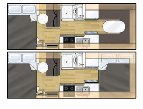
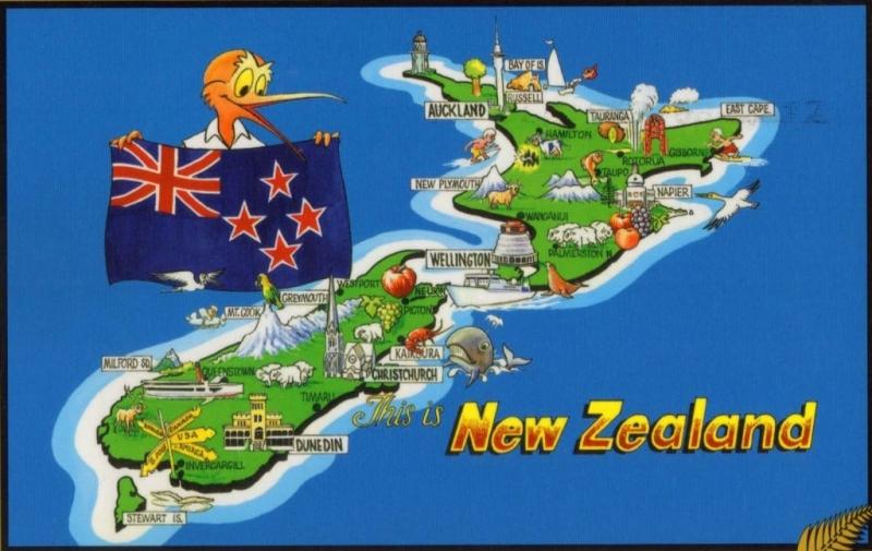


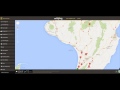


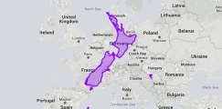

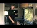
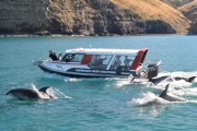
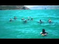
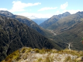
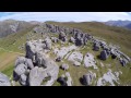
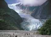


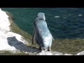
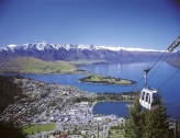

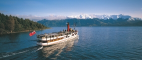

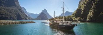

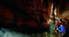
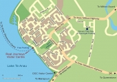


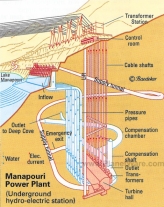


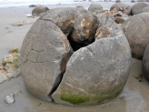
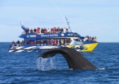


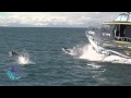

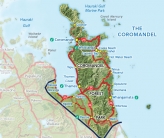


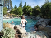
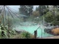

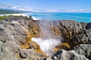

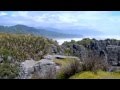

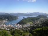
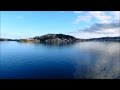
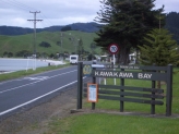
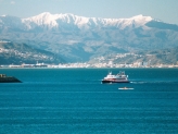


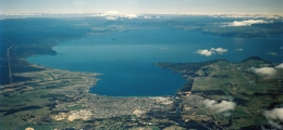
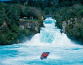


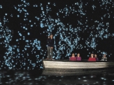


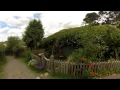
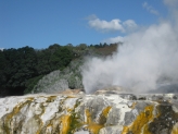
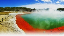


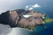
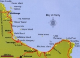

 |
| 


Comments